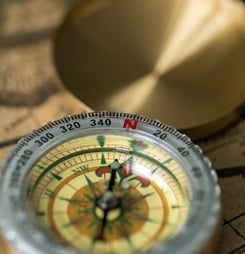

World Orienteering Day invites people to explore the outdoors with a map and compass. Participants navigate through forests, parks, or urban areas, aiming to find specific checkpoints.
This activity combines physical movement with mental challenges, making it both fun and engaging. It’s suitable for individuals of all ages and fitness levels, encouraging them to think on their feet while enjoying nature.
Beyond the adventure, this day promotes valuable life skills. Participants enhance their decision-making abilities, spatial awareness, and self-confidence. Engaging in orienteering can also improve physical health and mental well-being.
Moreover, it fosters a sense of community, as people come together to share experiences and learn from one another. Through these activities, World Orienteering Day highlights the joy of discovery and the benefits of active living.
World Orienteering Day Timeline
Early Military Orienteering in Sweden
Swedish military officers begin using timed map-and-compass cross‑country navigation exercises, a forerunner of modern orienteering as a sport.
First Known Public Orienteering Competition
A public orienteering race organized by Major Ernst Killander takes place near Stockholm, marking the transition from military training to civilian sport.
Modern Foot Orienteering Takes Shape
Ernst Killander formalizes rules and promotes orienteering among youth clubs and sports associations in Sweden, helping standardize the modern format.
First International Orienteering Conference
Officials from several European countries meet in Stockholm to discuss common rules and mapping standards, laying groundwork for international governance.
Founding of the International Orienteering Federation
National orienteering bodies from 10 countries create the IOF to govern the sport worldwide and coordinate international competitions.
First World Orienteering Championships
The inaugural World Orienteering Championships are held in Fiskars, Finland, establishing orienteering as a recognized international elite sport.
Electronic Punching and Mapping Advances
Electronic punching systems and digital cartography begin to be widely adopted, improving timing accuracy and course setting for orienteering events.
How to Celebrate World Orienteering Day
World Orienteering Day offers a chance to enjoy the outdoors while sharpening your navigation skills. Here are some fun and accessible ways to participate.
Design a Backyard Course
Transform your garden into an orienteering course using everyday items. Place markers around the area and create a simple map.
Invite friends or family to find each point using the map. This activity encourages exploration and teamwork.
Explore a Local Park
Visit a nearby park and set up a temporary orienteering trail. Use natural landmarks as checkpoints. Provide participants with maps and compasses to navigate the course.
This promotes physical activity and environmental awareness.
Organize a School Event
Teachers can incorporate orienteering into physical education classes. Set up a course on school grounds and teach students basic navigation skills.
This hands-on approach makes learning engaging and interactive.
Host a Community Challenge
Coordinate with local organizations to host a community-wide orienteering event. Create courses suitable for various skill levels.
Encourage participation through social media and local advertising. This fosters community spirit and healthy competition.
Try Virtual Orienteering
For those unable to attend in-person events, virtual orienteering offers an alternative. Use online platforms that simulate navigation challenges. This option provides accessibility and convenience.
History of World Orienteering Day
World Orienteering Day started in 2016. The International Orienteering Federation, known as the IOF, created this special event.
Their goal was to make orienteering more popular, especially among young people. Orienteering is an outdoor activity where people use a map and compass to find checkpoints. It mixes exercise with problem-solving, making it both fun and educational.
The first event saw a huge response. Over 250,000 people from many different countries joined in. They took part in orienteering activities at schools, parks, and clubs. Some ran through forests, while others explored city streets. Everyone had the same goal—to learn and enjoy the sport together.
Since that first year, the event has kept growing. More schools and groups plan activities every time it comes around.
This helps people of all ages discover orienteering for the first time. It also brings communities closer, as people work in teams or compete for fun.
The IOF continues to lead the event each year. They encourage clubs, teachers, and families to take part.
World Orienteering Day helps spread knowledge about map reading, navigation, and outdoor adventure. It reminds people that learning can happen anywhere, even outside, with a simple map in hand.
Facts About World Orienteering Day
Military Roots of Modern Orienteering
Orienteering grew out of 19th‑century military training, when Scandinavian armies began using timed cross‑country navigation exercises with map and compass to prepare officers for moving troops through unfamiliar terrain.
The first recorded use of the term in this sense was by the Swedish military in the late 1800s, and early civilian competitions were often organized by military officers who adapted these training drills into a sport.
The First Public Orienteering Competition
The first major public orienteering competition generally recognized by historians took place in 1919 near Stockholm, Sweden, organized by Major Ernst Killander.
Designed to attract young people to athletics, it combined detailed topographic maps, timed cross‑country running, and control points, establishing many of the competitive formats and rules that would later define the sport worldwide.
How Orienteering Maps Differ from Hiking Maps
Orienteering maps are far more detailed than standard hiking or tourist maps, typically drawn at scales like 1:10,000 or 1:15,000 and including features such as individual boulders, small depressions, and subtle vegetation boundaries.
They are also standardized through the International Specification for Orienteering Maps, which sets precise symbols and colors so that competitors from any country can quickly interpret terrain features while running at speed.
A Recognized International Sport with Dozens of Nations
From its Nordic origins, orienteering has grown into a globally organized sport governed by the International Orienteering Federation, which has more than 70 national member federations across every inhabited continent.
The sport has been included in multi‑sport events such as The World Games since 2001, where it appears alongside other non‑Olympic international disciplines.
Navigation and the Brain’s “Cognitive Map”
Research on navigation shows that reading maps and choosing routes engages brain regions such as the hippocampus and parietal cortex, which are involved in building “cognitive maps” of space.
Studies of London taxi drivers, for instance, found that those who regularly navigate complex street networks have larger posterior hippocampi, suggesting that intensive wayfinding practice can be linked with structural brain adaptations.
Orienteering as a Tool for STEM and Outdoor Education
Many schools and youth organizations use orienteering to teach real‑world applications of math, geography, and science by having students interpret map scales, contours, and magnetic declination while working in outdoor settings.
Educational bodies in countries like the United Kingdom and Australia include orienteering in physical education or outdoor learning curricula because it combines cardiovascular activity with problem solving and spatial reasoning.
Low‑Impact by Design on Natural Environments
Compared with many outdoor sports, orienteering is designed to have a relatively low environmental footprint, with organizers encouraged to avoid sensitive habitats, limit repeated foot traffic, and coordinate with land managers.
The International Orienteering Federation’s environmental guidelines recommend measures such as seasonal restrictions, careful course planning, and restoration of temporary markings so that events can be held in forests and parks without long‑term ecological damage.
World Orienteering Day FAQs