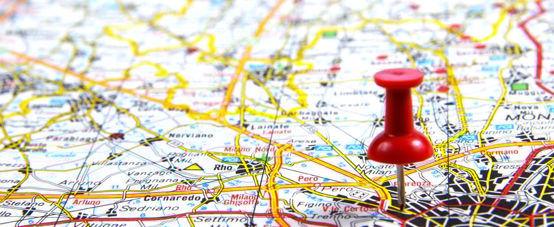
National Read a Road Map Day
Take yourself back to a time before built-in-GPS and smartphones in every pocket, and feel the thrum of adventure from reading a simple, tangible road map.
“The road goes every onward”, but where does the road in fact go? We could always ask our handy-dandy GPS, but National Read a Road Map Day a day dedicated to going back before the time of such handy little devices.
Instead it heralds back to a time when it was actually possible to hold a road map upside down, or stand over the hood of your car on the side of the road with it spread out.
The map represented adventure, it represented places unseen and roads untraveled, and was the ultimate guide back to where we started. If we could find out where we were on it.
National Read a Road Map Day Timeline
c. 350 CE
Roman Tabula Peutingeriana
A long scroll map depicting the Roman Empire’s road network shows major routes from Britain and North Africa to the Near East, illustrating one of the earliest surviving schematics of overland travel corridors.
1675
John Ogilby’s Britannia Atlas
English cartographer John Ogilby publishes “Britannia,” a pioneering road atlas of England and Wales that uses strip maps and a standardized mile, helping travelers follow plotted routes between towns.
1904
Early Automobile Road Map by Rand McNally
Chicago publisher Rand McNally issues one of the first U.S. road maps designed for motorists, the “New Automobile Road Map of New York City & Vicinity,” signaling a shift from rail to car-oriented cartography.
1916
Good Roads Movement and State Highway Maps
Following the Federal Aid Road Act, state highway departments begin systematically publishing official road maps, giving American drivers standardized visual guides to emerging state and federal routes.
1924
First Official U.S. Numbered Highway System
The Joint Board on Interstate Highways approves a numbered U.S. highway system, and cartographers quickly incorporate the shielded route numbers into printed maps, making long-distance navigation far easier.
1920s–1930s
Free Gas Station Maps for Motorists
Oil companies such as Gulf, Standard Oil, and Shell begin distributing free folded road maps at service stations, popularizing casual road trips and teaching millions of drivers how to read highway maps.
2000
GPS Available for Civilian Navigation
After the U.S. removes “selective availability” from GPS signals in 2000, consumer receivers and later smartphones provide accurate turn-by-turn directions, sharply reducing everyday reliance on paper road maps.
How to Celebrate National Read a Road Map Day
Read a Map
On this day, it’s time to bust out an old paper map, it doesn’t even have to be a recent one, and discover the wonders that these maps hold. No one says the map you read even has to be recent!
Ever found yourself curious about the roads that Rome was so famed for? There are maps that exist for those, showing what ends of the earth they all travelled to.
But let’s assume you’re going to stick to a more modern map. Now we’re going to give you a tutorial on how to read one!
Find a Local Map
The first thing you’re going to want to do is get your hands on is a map of your local area, and a Road Atlas.
This last is particularly useful, as it includes a national map plus one of each state. You can generally find these in gas stations, bookstores, supermarkets, or if nothing else you can locate one online.
You’re going to want to get one that’s been printed within the last three or four years to make sure they’re accurate. Nothing worse than finding out a road or highway on a map has changed names and you’re driving right by it!
Get Into the Details
The next step is an easy one, you’ll note that almost all maps, and especially the atlas, will have a grid laid out, numbered going one direction, lettered going the other.
You can use these to find the co-ordinates of your starting point, and your destination. If you check the back of the atlas or map, you’ll find that prominent towns are listed by their coordinates on the map.
Locating and marking these with removable stickers will make finding them easier in the future, and give you a clear idea of your route.
Make a Route
The next step is doing just that, finding your route! There’s usually more than one way to get from a starting point to a destination, and there’s lots of options to take along the way.
If a highway is available, those generally serve as the most direct route between two points, otherwise you’ll have to look for main roads, and side roads. It’s always a good idea to check out all of these to find the route that suits your needs, after all, the highway is fast, but it’s not much for taking in the scenery.
The way you can tell what all of these are is by checking out the ‘legend’ or ‘key’ on the side of the map. These lists of symbols will tell you how to identify cities, highways, interstates, country roads, unpaved roads and side roads, and manmade landmarks.
Lots of different options for the intrepid traveler. By taking the time to look over the map and study its contents, you’ll make sure you’re never lost, even when your phone battery dies and your GPS cuts out. All of this gained by doing just one simple thing! Celebrating National Read a Road Map Day!
National Read a Road Map Day
Roman Route Lists Worked More Like Timetables Than Maps
Long before modern road atlases, Romans used written “itineraries” that listed routes as sequences of place names with distances, almost like a timetable rather than a picture of space.
The Antonine Itinerary, compiled in the 3rd century, records some 225 routes across the empire, giving mileages between towns so travelers could calculate journey lengths even without a visual map.
The Tabula Peutingeriana Stretches the Roman World into a Strip Map
One of the most famous survivals of Roman road mapping is the Tabula Peutingeriana, a medieval copy of a late Roman map that compresses Europe, North Africa, and parts of Asia into a long, narrow strip. Rather than showing realistic geography, it emphasizes connections along the road network, foregrounding routes, way stations, and distances over accurate shapes of coastlines or countries.
The First Surviving Topographic “Road Map” Comes from Ancient Egypt
What is often called the world’s oldest surviving topographic map is the Turin Papyrus Map from around 1150 BCE, drawn for an Egyptian mining expedition in the Wadi Hammamat.
It shows hills, quarries, temples, and routes with colors and annotations, giving not just directions but information about resources and hazards along the way, a concept that reappears in modern road atlases with symbols for services and terrain.
John Ogilby’s 1675 Britannia Turned Roads into Measured Strip Maps
In 17th‑century England, John Ogilby’s “Britannia” (1675) standardized the mile at 1,760 yards and published 100 detailed strip maps of major roads.
Each plate shows a route as a series of parallel strips with mile markers, river crossings, and towns, arranged so travelers could follow a road visually and know exact distances, much like following a modern state highway map.
Automobile Road Maps Emerged with the Car Itself
Purpose-made road maps for motorists appeared soon after cars became practical. In the United States, Rand McNally issued its “New Automobile Road Map of New York City & Vicinity” in 1904, using a special wax engraving process to mass-produce detailed highway information at low cost, which helped make the road atlas a staple of early 20th‑century car travel.
Gas Stations Once Gave Away Millions of Free Road Maps
During the mid‑20th century “golden age” of motoring, American oil companies treated road maps as marketing tools and distributed them for free at service stations.
By the 1960s, firms such as Gulf, Texaco, and Shell collectively printed tens of millions of state and regional maps annually, often branded with their logos, which shaped how drivers pictured national and state highway networks.
Paper Maps May Strengthen Spatial Memory More Than GPS
Studies in cognitive psychology suggest that people who learn an area using paper maps often build stronger “survey knowledge” of the layout than those who follow turn‑by‑turn GPS instructions.
Experiments have found that GPS users tend to remember fewer landmarks and have more trouble drawing accurate sketch maps afterward, while map users develop a more flexible mental model of the environment.
Also on ...
View all holidays
Geologists’ Day
Don’t take the ground beneath your feet for granted: honor the scientists that have delved into the Earth to teach us more about it on National Geologist’s Day.

First Contact Day
On April 5th, 2063, Zefram Cochrane makes first contact between man and extraterrestrials: this day is for Trekkies everywhere to let their geekdom out.

Gold Star Spouses Day
Courageous partners, facing loss with resilience, forming an unspoken bond—a testament to strength beyond words.
We think you may also like...

Independent Bookstore Day
Independent bookstores are struggling more and more with competition like Amazon or big chains like Barnes & Noble, so make a point to support your local shop.

Star Wars Day
May the Fourth be with you. Fans of George Lucas’ iconic global phenomenon get to geek out extra hard on this pun-centric, nerd-friendly holiday.

World Read Aloud Day
Sharing stories with spoken words, weaving tales that come to life through the voice, and creating a cozy connection between listener and narrative.

Freelance Writers Appreciation Week
With nimble fingers and creative minds these wordsmiths create content that speak to the hearts of readers everywhere.